

Things To Do
Pikes Peak is one of the most famous mountains in America. It towers over Colorado Springs and has served as a waypoint and rallying cry since the gold rush days, when miners crossed the country with “Pikes Peak or bust” painted on their wagons.
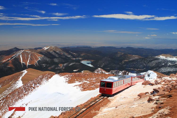
The peak is the centerpiece of this National Forest. There are three ways to reach the top: taking the Pikes Peak Cog Railway; driving or biking up the Pikes Peak Highway; or hiking. Hikers can take Barr Trail, the 12.6-mile hike that begins in Manitou Springs and passes through every ecological zone Colorado has to offer. A shorter hike, though still a long day, can be done on the peak’s west side from The Crags. The National Forest offers many other trails within a close drive of the city, which might explain why so many people in Colorado Springs hike and bike.
Leaving the city behind, the forest expands northwest past Woodland Park through the Rampart Range, a chain of low-forested hills that runs all the way north to the Denver suburbs. This area is popular with off-highway-vehicle enthusiasts, though it does offer the very popular hike up Devil’s Head, one of the last manned fire lookouts in the West. Much of this area was burned in the 2012 Waldo Canyon Fire. While some areas like Rampart Reservoir have reopened since then, the area will remain a shadow of its former self for generations to come.
As the forest rolls west, it looks less like a forest and more like a matchstick graveyard. In 2002, a year of severe drought, a U.S. Forest Service employee burning love letters accidentally started the Hayman Fire, the most destructive to date in Colorado. It destroyed 133 homes and left 138,000 acres burned. Few come here for recreation.
Lost Creek Wilderness is another story. This gem of a wilderness, known for amazing backpacking trails and rock domes, cliffs and spires to rival Yosemite, was largely spared from the fire. Every hiker from Denver or Colorado Springs should visit this wilderness in their lifetimes.
The National Forest ends where the hills give way to the massive valley of South Park, forming a horseshoe around the valley’s west, north and east sides. Beneath the high peaks of the Front Range, hikers will find numerous trails to get them above the valley floor. Boreas Pass Road, the original train route to Breckenridge from Como, makes a great summer or autumn drive or winter cross-country ski.
Finally, at Hoosier Pass on the Continental Divide the forest turns south, encompassing the east side of the Mosquito Range. Most visitors come here to hike the four popular fourteeners or drive the four-wheel-drive roads, historic routes to the mines around Leadville. The National Forest ends at the Buffalo Peaks Wilderness. Perhaps the least-visited part of the forest, this wilderness offers solitude and abundant wildlife.
Pro Tips
Our Favorite Trails
Fishing
Scenic Drives
Winter Sports
This National Forest has no ski area, and much of it is too low to hold consistent snow, but winter sports enthusiasts can still enjoy it. The Crags area on the west side of Pikes Peak offers scenic snowshoeing, and in spring skiers take runs off the Pikes Peak Highway above Glen Cove. Otherwise you need to look farther west. The Boreas Pass Road offers great skiing to a cabin, the Section House, with reserveable bunks in winter. Elsewhere, the snow-covered slopes on either side of Hoosier Pass offer reliable snow for sledding and skiing.
Recommended season(s): Year-round.
—R. Scott Rappold


(0) comments
Welcome to the discussion.
Log In
Keep it Clean. Please avoid obscene, vulgar, lewd, racist or sexually-oriented language.
PLEASE TURN OFF YOUR CAPS LOCK.
Don't Threaten. Threats of harming another person will not be tolerated.
Be Truthful. Don't knowingly lie about anyone or anything.
Be Nice. No racism, sexism or any sort of -ism that is degrading to another person.
Be Proactive. Use the 'Report' link on each comment to let us know of abusive posts.
Share with Us. We'd love to hear eyewitness accounts, the history behind an article.