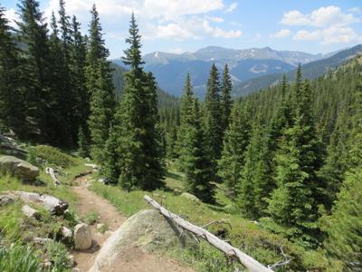
Mount Yale is an unmistakable mountain, towering like a pyramid over the Arkansas River Valley. The southwest slopes trail is the standard route up Yale, and yes it is steep, gaining 4,300 feet of elevation in 4.5 miles. It begins off the Cottonwood Pass road at the Denny Creek Trailhead and rises modestly through the forest for 1.25 miles. Turn right at an intersection – straight goes to Hartenstein Lake and Brown’s Pass – and continue through the forest to timberline. The trail is obvious as it rises through the tundra. It becomes very steep as it ascends a ridge to a shoulder of Yale at 13,200 feet. Then it gets even steeper, as the final stretch and Yale’s pointed summit come into view. Follow cairns marking the route as you scramble up the final stretch to the summit. Take a picture, catch your breath and enjoy the feeling of standing at 14,196 feet.
Pro Tips
Recommended season(s): Summer – early fall.
—R. Scott Rappold


(0) comments
Welcome to the discussion.
Log In
Keep it Clean. Please avoid obscene, vulgar, lewd, racist or sexually-oriented language.
PLEASE TURN OFF YOUR CAPS LOCK.
Don't Threaten. Threats of harming another person will not be tolerated.
Be Truthful. Don't knowingly lie about anyone or anything.
Be Nice. No racism, sexism or any sort of -ism that is degrading to another person.
Be Proactive. Use the 'Report' link on each comment to let us know of abusive posts.
Share with Us. We'd love to hear eyewitness accounts, the history behind an article.