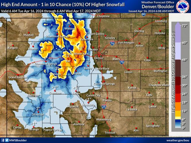


The comparison between the National Weather Service's 'high-end' snowfall scenario (which has a 10-percent chance of manifesting) and the 'expected' snowfall scenario depict two very different situations in the Colorado high country through Wednesday morning.
Should the less-likely high-end scenario take place, parts of the mountainous region in the area of the state's northern portion of the Continental Divide could get up to 24 inches of additional snow after big totals of up to 24 inches in the same area over the past 24 hours. This includes the Winter Park area and Rocky Mountain National Park, with mountains near Vail, Aspen, Steamboat Springs, and Glenwood Springs also getting more than a foot of snow in this scenario.
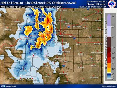
That being said, in the 'most likely' snowfall scenario, the mountains still get snow, but only a few small pockets get more than six inches. Most mountains get between zero and four inches.
What's notable about this gap in snowfall between the 'high-end' and 'expected' snowfall scenario is how wide-ranging snowfall could be. Generally, that gap isn't quite as large.

The expected and most likely snowfall scenario through Wednesday morning. Photo Credit: National Weather Service.
Either way, Coloradans headed to the mountains on Tuesday into Tuesday night should be prepared for the potential of heavy snowfall, particularly those entering the central mountain and northern mountain regions. If heavy snow does land, it will be stacking on top of the 12 to 24 inches that has already landed in the same part of the state in the last 24 hours. Travel concerns may exist due to deep and blowing snow. Various winter weather alerts have been activated in the impacted areas.
Despite the big snow of the past 24 hours, snowpack was being reported at about 99 percent of what's typical for this time of the year in the early morning hours of April 16. It's likely a little bit of a jump will be seen as these numbers are updated tomorrow and Thursday.
Follow along with weather updates on the National Weather Service website.


(1) comment
hype on more hype
Welcome to the discussion.
Log In
Keep it Clean. Please avoid obscene, vulgar, lewd, racist or sexually-oriented language.
PLEASE TURN OFF YOUR CAPS LOCK.
Don't Threaten. Threats of harming another person will not be tolerated.
Be Truthful. Don't knowingly lie about anyone or anything.
Be Nice. No racism, sexism or any sort of -ism that is degrading to another person.
Be Proactive. Use the 'Report' link on each comment to let us know of abusive posts.
Share with Us. We'd love to hear eyewitness accounts, the history behind an article.