


Snow returns Tuesday into Wednesday with a short pause on Thursday before a 5-6 day snow event ramps up heading into Easter weekend and early next week.
Tuesday's moment of ZEN:
Skier Bruce Ruff of Golden enjoys some powder skiing under Chair 8 Monday, March 24, 2024 at Loveland Ski Area in Georgetown, Colorado.
Recap:
On Monday, 2-6 inches of additional snow fell from lingering showers as the low pressure system from the weekend moved farther east.
Forecast:
On Tuesday, light powder awaits skiers and riders for first chairs mostly in the northern mountains. Snow should start developing again in the afternoon and is forecast to focus on the central, western and southern mountains, with between 2-4 inches, potentially up to 8 inches in the northern San Juan mountains, falling by Wednesday's first chairs. High temperatures will be in the 20s with wind chills below zero.

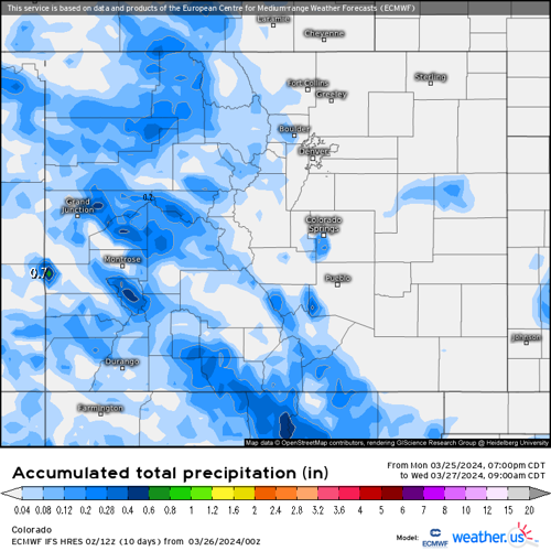
A Weather.us forecast map from the ECMWF model shows the potential total accumulation levels of water-equivalent precipitation as of 9 a.m., Wednesday, March 27 for Colorado. Depending on the density of the snow, one inch of water is equivalent to 10 inches of snow based on a common rule of thumb ratio of 10:1.
On Wednesday morning, more snow continues to accumulate for Thursday's first chairs, with another 1-3 inches possible.
Thursday is a transition day as Colorado will be between storms but temperatures remain more winter like with high temperatures staying in the high 20s and low 30s even with some sun peeking through the clouds.
Long Range:
Starting Friday, a broken-off wave of energy from a low pressure system off the Oregon coast is forecast to make its way into the interior west, bringing snow to the north and central mountains.

A Weather.us forecast map from the ECMWF model shows the potential total accumulation levels of water-equivalent precipitation as of 10 a.m., Saturday, March 30 for Colorado. Depending on the density of the snow, one inch of water is equivalent to 10 inches of snow based on a common rule of thumb ratio of 10:1.
Early model runs from the ECMWF high resolution model have 6-10 inches falling in the central mountains, 4-8 inches in the northern mountains and 8-14 inches in the northwestern mountains for Saturday's first chairs. Steamboat and Aspen/Snowmass areas should see the most from this west to east flowing storm energy.
As the low moves further south along the west coast, additional storm waves will push inland toward the Four Corners region, with snow ramping up in the southern mountains as well for Monday's first chairs.

A Weather.us forecast map from the ECMWF model shows the synoptic composite of wind speeds, atmospheric pressure and humidity levels of the air for 10 a.m., Sunday, March 31, for the United States. The reds, yellows and oranges represent moister air and the greens, blues and purples represent less moist air.
Additional snow accumulations between 3-6 inches in the northern and central mountains and 2-4 inches in the southern mountains is forecast.
On Monday, the low pressure system works its way into the Arizona desert and will push moisture into Colorado on southwest flows, creating a possible heavy snow event throughout the day into Tuesday.

A Weather.us forecast map from the ECMWF model shows the synoptic composite of wind speeds, atmospheric pressure and humidity levels of the air for 7 a.m., Monday, April 1, for the United States. The reds, yellows and oranges represent moister air and the greens, blues and purples represent less moist air.
Snow is forecast to fall for all mountain regions during this quick moving and stronger storm, with the potential for 10-18 inches accumulated by Tuesday's first chairs into mid-morning.
Wednesday and Thursday should be dry and sunny with warming temperatures ahead of a potential storm system arriving from the northwest on Friday.
Today's 24 hour snow totals from Colorado resorts:
Arapahoe Basin - 3"
Aspen Mountain - 2"
Aspen Highlands - 1"
Beaver Creek - 2"
Breckenridge - 5"
Buttermilk - 0"
Cooper - 0"
Copper Mountain - 2"
Crested Butte - 0"
Echo Mountain - 0"
Eldora Mountain - 0"
Granby Ranch - 0"
Hesperus - Closed for season
Howelsen Hill - Closed for season
Kendall Mountain - Closed for season
Keystone - 2"
Loveland - 1"
Monarch - 1"
Powderhorn - 0"
Purgatory - 0"
Silverton - 0"
Snowmass - 2"
Steamboat - 3"
Sunlight - 0"
Telluride - 3"
Vail - 5"
Winter Park - 4"
Wolf Creek - 2"


(0) comments
Welcome to the discussion.
Log In
Keep it Clean. Please avoid obscene, vulgar, lewd, racist or sexually-oriented language.
PLEASE TURN OFF YOUR CAPS LOCK.
Don't Threaten. Threats of harming another person will not be tolerated.
Be Truthful. Don't knowingly lie about anyone or anything.
Be Nice. No racism, sexism or any sort of -ism that is degrading to another person.
Be Proactive. Use the 'Report' link on each comment to let us know of abusive posts.
Share with Us. We'd love to hear eyewitness accounts, the history behind an article.