


The National Weather Service has issued a winter weather advisory for parts of the central and northern mountain regions in Colorado, set to be in effect from 6 p.m. on Friday until 9 a.m. on Saturday – and the Denver metro could be impacted by the weather, too.
The alert encompasses where the most severe weather should be located, including areas of Rocky Mountain National Park and the Medicine Bow Range, the mountains of Summit County, the Mosquito Range, and the Indian Peaks, the Northern Front Range foothills, and the Southern Front Range foothills.
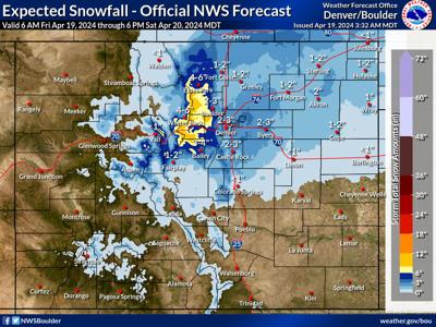
Roughly four to 10 inches of snow is expected in this area, but in a high-end snowfall scenario, some peaks could get as much as 18 inches. It's also worth noting that while downtown Denver is only expected to get about two to three inches in the most likely scenario, up to five inches could fall.

The 'high-end' 10-percent-chance snowfall scenario. Map Credit: National Weather Service.
The main concern associated with the alert is dangerous travel due to winter conditions, expected to be especially problematic on Friday evening.
According to OpenSnow, Eldora Mountain is set to get the most snow over the next five days – up to 10 inches. With the resort set to end their season on April 21, it's looking like some fresh powder will be present during their final two days of operations.
As of April 19, the statewide snowpack in Colorado is at 98 percent of what's normal for this point in the season.
Find additional information about the National Weather Service winter weather advisory and snowfall forecasting here.


(0) comments
Welcome to the discussion.
Log In
Keep it Clean. Please avoid obscene, vulgar, lewd, racist or sexually-oriented language.
PLEASE TURN OFF YOUR CAPS LOCK.
Don't Threaten. Threats of harming another person will not be tolerated.
Be Truthful. Don't knowingly lie about anyone or anything.
Be Nice. No racism, sexism or any sort of -ism that is degrading to another person.
Be Proactive. Use the 'Report' link on each comment to let us know of abusive posts.
Share with Us. We'd love to hear eyewitness accounts, the history behind an article.