


Snow showers, then heavier snow showers, then SNOW, before less snow to end the last weekend of April at Colorado's remaining open ski areas and resorts.
Winter's last hurrah starts Thursday and lasts until Sunday via two low pressure systems before a major shift into spring-like weather begins in the high country to start May.
Recap:
On Wednesday, warmth could be had around Colorado's mountains, with partly sunny skies and temperatures in the 50s. Winter Park recorded a high of 53 according to Accuweather.
Forecast:
On Thursday, temperatures will reach into the low 50s again, however, beginning Thursday night, rain will eventually turn over to snow sometime Friday after sunset as a prolonged period of snow is forecast to start, with snow accumulating through Sunday morning.
Snow showers:
Snow levels will stay above 10,000 feet initially on Thursday night, climb near 11,000 feet on Friday before falling again Friday night into Saturday. Purgatory's and Winter Park's base-area elevations are around 9,000 feet, meaning the potential for a rain/snow mix to begin the snow-event is possible, however by Saturday heavy, wet snow should be falling below 9,000 feet.
The German ICON model forecasts snow totals between 1-4 inches for Friday's first chairs, including Purgatory.

A Weather.us forecast map from the ICON model shows the potential total accumulation levels of water-equivalent precipitation as of 10 a.m., Friday, April 26 for Colorado. Depending on the density of the snow, one inch of water is equivalent to 10 inches of snow based on a common rule of thumb ratio of 10:1.
Heavier snow showers:
On Friday, snow showers continue and pick up throughout the afternoon and evening, especially in the San Juan, Elks and Front Range mountains, as long as the temperatures stay low enough. Potential additional forecasted snow totals of between 8-10 inches for Saturday's first chairs, including Purgatory, are possible, with upwards of 16 inches in Rocky Mountain National Park, Cameron Pass and the eastern Front Range mountains.

A Weather.us forecast map from the ICON model shows the potential total accumulation levels of water-equivalent precipitation as of 10 a.m., Saturday, April 27 for Colorado. Depending on the density of the snow, one inch of water is equivalent to 10 inches of snow based on a common rule of thumb ratio of 10:1.
SNOW:
On Saturday, it's pretty much going to snow all day above 9,000 feet. The National Weather Service in Boulder is calling for a 100% chance of snow from Winter Park to Purgatory. Potential additional snow totals of between 8-12 inches for Sunday's first chairs, with another 4-10 inches in RMNP, Cameron Pass and the eastern Front Range mountains, are forecast.

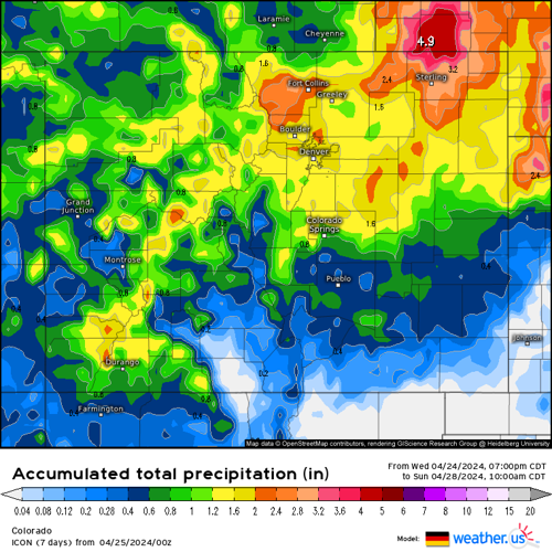
A Weather.us forecast map from the ICON model shows the potential total accumulation levels of water-equivalent precipitation as of 10 a.m., Sunday, April 28 for Colorado. Depending on the density of the snow, one inch of water is equivalent to 10 inches of snow based on a common rule of thumb ratio of 10:1.
Snow will wind down on Sunday afternoon, but not after delivering between 2-7 more inches statewide.
Less snow:
Monday could be a left over spring-powder day, however, if the snow is still dense from the warmer temperatures during the storm, it might settle quickly Sunday night and overnight, giving Monday's first chairs manky or mashed potato-like consistency.
Snow accumulation grand total potentials:
• Northern mountains: 18-24"
• Central mountains: 12-20"
• Southern mountains: 14-20"
For Monday through Wednesday, gradual warming each day with sunny skies and highs in the 50s will greet skiers and riders of the five remaining open ski areas. Monday will be the windiest day of the three, but near perfect spring conditions will return after the large-scale snow event from the weekend.
Long Range:
From May 2-8, the National Oceanic and Atmospheric Administration's 8-14 day temperature outlook forecasts nearly all of Colorado's mountainous regions to experience above normal average temperatures of between 40%-50%.

A map of the 8-14 day temperature outlook for the United States from May 2-8, 2024, shows above average temperatures for over 60% of the nation, including Colorado with the state's mountainous regions 40%-50% above average.
Convective snow showers or thunder snow is possible Thursday and Friday in the 10-day outlook, but this might be the end of fresh, spring-snow or spring-powder for skiing and riding season 2023-24.
Copper Mountain is hosting its Slush Rush competition near the American Eagle chairlift and Superpipe on Saturday. The Denver Gazette will be covering some of the day's fun and events, with text, photos and video to enjoy from the mayhem that certainly will ensue. Check back Monday for a wrap up.
Today's 24 hour snow totals from Colorado resorts:
Arapahoe Basin - 0"
Breckenridge - 0" (Parts of Peak 8, plus Peaks 9 and 10 closed)
Copper Mountain - 0"
Loveland - 0"
Purgatory - 0" (Open Fri-Sun)
Winter Park - 0"
Aspen Highlands - Closed for season
Aspen Mountain - Closed for season
Beaver Creek - Closed for season
Buttermilk - Closed for season
Cooper - Closed for season
Crested Butte - Closed for season
Echo Mountain - Closed for season
Eldora Mountain - Closed for season
Granby Ranch - Closed for season
Hesperus - Closed for season
Howelsen Hill - Closed for season
Kendall Mountain - Closed for season
Keystone - Closed for season
Monarch - Closed for season
Powderhorn - Closed for season
Silverton - Closed for season
Snowmass - Closed for season
Steamboat - Closed for season
Sunlight - Closed for season
Telluride - Closed for season
Vail - Closed for season
Wolf Creek - Closed for season


(0) comments
Welcome to the discussion.
Log In
Keep it Clean. Please avoid obscene, vulgar, lewd, racist or sexually-oriented language.
PLEASE TURN OFF YOUR CAPS LOCK.
Don't Threaten. Threats of harming another person will not be tolerated.
Be Truthful. Don't knowingly lie about anyone or anything.
Be Nice. No racism, sexism or any sort of -ism that is degrading to another person.
Be Proactive. Use the 'Report' link on each comment to let us know of abusive posts.
Share with Us. We'd love to hear eyewitness accounts, the history behind an article.