
With so many different wildfires burning around Colorado, there's a good chance you haven't heard of Teddy's Peak fire yet.
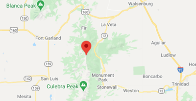
Teddy's Peak Fire is a 2-acre blaze that sparked on October 21 in southern Colorado in Huerfano County – home to Walsenburg. It's found four miles southwest of Cuchara, Colorado between Bear and Blue Lakes, which are found in the Cuchara River drainage. It is zero percent contained.
While much smaller than Colorado's other wildfires, some suppression efforts were prevented today due to strong winds. As wind speeds climbed, airtankers and helicopters were forced to halt operations that could slow the blaze, as of a 2:25 PM update. Previous updates indicated that a helicopter had been en route prior in the day and that an air attack was on scene. Yesterday, multiple drops were made.
Read more here.


(0) comments
Welcome to the discussion.
Log In
Keep it Clean. Please avoid obscene, vulgar, lewd, racist or sexually-oriented language.
PLEASE TURN OFF YOUR CAPS LOCK.
Don't Threaten. Threats of harming another person will not be tolerated.
Be Truthful. Don't knowingly lie about anyone or anything.
Be Nice. No racism, sexism or any sort of -ism that is degrading to another person.
Be Proactive. Use the 'Report' link on each comment to let us know of abusive posts.
Share with Us. We'd love to hear eyewitness accounts, the history behind an article.