
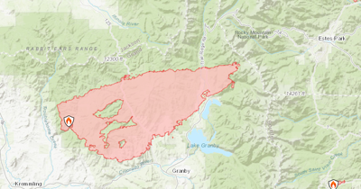
Mapping of the East Troublesome Fire, which exploded more than 100,000 acres in a 24-hour period, shows that the blaze has entered Rocky Mountain National Park and crossed over Trail Ridge Road.
It is unclear how much damage has been done. Fire officials confirmed that the blaze has burnt at least to timberline. Additional growth is expected on Thursday and there's a possibility for the 125,602-acre East Troublesome Fire and the 206,977-acre Cameron Peak Fire to merge.
Rocky Mountain National Park has been shut down to visitors.
Trail Ridge Road is an iconic Colorado drive and the highest continuous paved road in Colorado. It reaches an elevation of 12,183 feet above sea level.
Find more East Troublesome Fire updates here.


(0) comments
Welcome to the discussion.
Log In
Keep it Clean. Please avoid obscene, vulgar, lewd, racist or sexually-oriented language.
PLEASE TURN OFF YOUR CAPS LOCK.
Don't Threaten. Threats of harming another person will not be tolerated.
Be Truthful. Don't knowingly lie about anyone or anything.
Be Nice. No racism, sexism or any sort of -ism that is degrading to another person.
Be Proactive. Use the 'Report' link on each comment to let us know of abusive posts.
Share with Us. We'd love to hear eyewitness accounts, the history behind an article.