
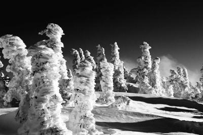
As a multi-day weekend storm approaches Colorado, expected totals are now falling in the two-to-three-foot range in some parts of the state.
According to the National Weather Service (NWS), Saturday through Monday night will likely bring two to three feet of snow to the southwestern San Juan Mountains, as well as one to two feet to the La Garita Mountains. The heaviest snowfall is currently predicted to drop on Saturday night and Sunday night.
The heavy snow in Colorado's southwest will be accompanied by strong winds, expected to reach up to 75 miles per hour on some high-elevation mountain passes. Travel is expected to be "very difficult to impossible" due to limited visibility caused by blowing snow. High profile vehicles should be especially cautious.
The National Weather Service is also predicting a few inches of snow on Saturday night in other mountainous regions, with additional light accumulation on the following day.
Joel Gratz of OpenSnow.com is also calling for big snow totals, including up to 40 inches in the southern part of Colorado and 5 to 12 inches in the central and northern mountains. Among the resorts, he's expecting Wolf Creek to get the most fresh powder – 24 inches over five days. While the resorts in the south are expected to see big totals, no resort along the I-70 corridor is expected to get more than 8 inches during that timeframe. Read his full forecast and see a resort-by-resort breakdown here.
Gratz is also calling for two additional potential snowstorms to follow next week. Read more about that here.
Due to the wild winter conditions that are likely about to hit the Centennial State, the National Weather Service has issued a Winter Storm Watch that's active through late Monday. See a map of the impacted area in the tweet below.
A Winter Storm Watch has been issued for the southwest mountains from late Friday night thru late Monday night. Heavy snow of 2-3 feet & strong wind gusts in excess of 75 mph will be possible, with the highest snowfall amounts expected across the Eastern San Juan Mountains. #cowx pic.twitter.com/imGUfPQYMe
— NWS Pueblo (@NWSPueblo) November 6, 2020
Despite the heavy snow and wintery weather that's set to hit parts of Colorado, other regions will continue to be relatively warm and dry this weekend.
The Colorado Springs area is expected to hit temperatures near 70 degrees on Saturday, staying sunny and in the 50s on Sunday with no current chance of precipitation on either day. Denver weather will be similar.
On the Western Slope, Grand Junction has a high of 62 on Saturday and a high of 50 on Sunday, with Saturday looking a bit rainy later on.
Those planning to recreate in Colorado's mountains should be prepared to encounter winter weather. Some of the state's highest peaks will be experiencing intense wind and snow. For example, Mount Sneffels in the southwest is predicted to see more than 25 inches on Saturday and wind speeds in the 40s. Along the Front Range, Longs Peak won't be seeing much snow, but wind speeds are expected to hit a dangerous 60 miles per hour with a Sunday morning windchill at negative 22 degrees.
As seasons change, it is crucial that Colorado's outdoor recreators keep a mindful eye to the sky, staying up-to-date with local forecasts throughout the course of planning and executing an adventure. Bring layers, prepare for possible stranding, and never be hesitant to turn back if conditions worsen.
Editor's Note: All weather predictions are obviously subject to rapid change. This IS Colorado, after all. Plan ahead and be aware of current weather predictions before embarking on an outdoor adventure or traveling across the state.


(0) comments
Welcome to the discussion.
Log In
Keep it Clean. Please avoid obscene, vulgar, lewd, racist or sexually-oriented language.
PLEASE TURN OFF YOUR CAPS LOCK.
Don't Threaten. Threats of harming another person will not be tolerated.
Be Truthful. Don't knowingly lie about anyone or anything.
Be Nice. No racism, sexism or any sort of -ism that is degrading to another person.
Be Proactive. Use the 'Report' link on each comment to let us know of abusive posts.
Share with Us. We'd love to hear eyewitness accounts, the history behind an article.