


In 1919, a young U.S. Forest Service ranger named Arthur Carhart was sent to high, remote reaches of northwest Colorado to scout land for homes and roads to be built.
He came to a clearing, where a lake reflected the majesty of flat-top mountains marching above the shores. This was no place for construction, Carhart decided.
He remarked on “areas that can never be restored to the original condition after man has invaded them, and the greatest value lying as it does in natural scenic beauty.”

Arthur Carhart’s vision of protecting “natural scenic beauty” helped spur the 1964 Wilderness Act.
It was a rather radical view in those early days of the Forest Service, which prioritized logging and grazing. Carhart had another thought: “Perhaps the rebuilding of the body and spirit is the greatest service derivable from our forests.”
Thus became the thinking for the 1964 Wilderness Act.
Sixty years later, Coloradans have that legislation to thank for 44 designated areas. They combine for 3.7 million acres — a land mass the size of Connecticut free of the ruin Carhart feared.
The Wilderness Act famously protects areas “where man himself is a visitor who does not remain.” And it was famously born there on the shores of Trappers Lake, surrounded by what is now Flat Tops Wilderness.
In this 60th anniversary year, what better time to plan a trip there or other mighty wilderness areas in Colorado?
Here’s a look at 10 showcasing that “greatest service” Carhart imagined:

Rosy paintbrush waving at John Fielder’s camera in the Collegiate Peaks Wilderness.
167,584 acres; near Buena Vista, Leadville; est. 1980
The wilderness boasts eight 14,000-foot mountains, leading the Forest Service to surmise it “probably possesses the highest average elevation of any wilderness in the Lower 48.”
Anyone who has climbed Mounts Harvard, Yale, Columbia, Oxford, Belford, Missouri Mountain or Huron or La Plata peaks can say they are familiar with Collegiate Peaks Wilderness. But not as familiar as those who have traveled the large sections of the Colorado Trail here. Two segments in the wilderness combine for a 160-mile loop.
You don’t need those grand ambitions to enjoy the embrace of the wilderness. With a high-clearance, four-wheel drive to start at the trailhead, it’s about 7 miles out and back to Lake Ann, a cerulean marvel overlooked by the Three Apostles thirteeners.

Nancy and Tom Gould of Denver hike the North Tenmile Creek Trail through turning aspens on Sept. 23, 2020, outside of Frisco. The trail leads into the Eagles Nest Wilderness Area.
133,496 acres; near Frisco, Silverthorne, Vail; est. 1976
Colorado’s central mountains were destined for development tied to the ski industry. Mountainsides carved by runs. Hotels and restaurants. Shops and condos.
But the same decade that saw Copper Mountain Resort come along also saw Congress set aside vast nature along Interstate 70 to be unspoiled. Welcome to Eagles Nest Wilderness, an escape as quick as the North Tenmile Creek trailhead right off I-70 in Frisco.
On the Silverthorne side, there’s the Lily Pad Lake trailhead. That’s a great, short option for families and day trippers from Denver. On the Vail side, Gore Creek trail runs about 11 miles out and back to Gore Lake — worthy of the craggy, namesake range defining the wilderness.

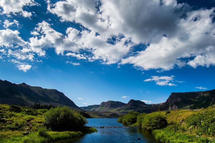
Trappers Lake is the second largest natural lake in Colorado behind Grand Lake and sits on the edge of the 230,830-acres Flat Tops Wilderness Area in northwestern Colorado.
235,214 acres; near Meeker, Yampa, Glenwood Springs; est. 1975
Carhart would be proud of what is now known nationwide as the “Cradle of Wilderness.” From Trappers Lake was born Colorado’s second-largest wilderness area, named for those basalt-capped cliffs looming all around this dreamy realm.
Perhaps the most striking geologic feature is the Chinese Wall. A trailhead is found after a long, climbing drive on a county road from Meeker. It’s a long, mesmerizing hike of land and sky atop the wall. Springing off it is another stunner: the hair-raising Devil’s Causeway, an exposed, steep and narrow spine.
Or one can relax at the scene that inspired it all. A Forest Service webpage details driving directions to Trappers Lake.

The Cascade Trail in the Indian Peaks Wilderness enters breathtaking clearings like these. Gazette photo
73,391 acres; near Boulder, Nederland, Winter Park, Grand Lake; est. 1978
The visitor does not remain, but the return is constant. With more than 150,000 people between Memorial Day and Labor Day, the Forest Service considers Indian Peaks one of America’s most-visited wilderness areas. That’s due to the proximity to Front Range populations.
In Boulder County, Brainard Lake Recreation Area and the Hessie trailhead are the most popular portals to some of the wilderness area’s 50 lakes and six passes over the Continental Divide. Brainard Lake Recreation Area requires a parking reservation, a shuttle serves Hessie, and for wilds beyond, backpackers will need overnight permits.
Many are called to Lone Eagle Peak, the triangular sentinel standing over Crater Lake. A nearly 15-mile round trip starts from the Monarch Lake trailhead on the wilderness’s Grand County side.

The morning sun outlines the volcanic rock formations in Wheeler Geologic Area near Creede in this July 6, 2020, photo.
129,626 acres; near Creede, South Fork, Lake City; est. 1964
Between the San Juan Mountains and San Luis Valley, the La Garita Mountains recall one of the most violent, volcanic eras known in world history. The events of some 40 million years ago helped render today’s stunning tapestry. It’s demonstrated well by Wheeler Geologic Area outside Creede.
“A truly remarkable site,” read a Forest Service report in 1907, referring to it as “an enchanted city” of “spires and domes, castles and cathedrals, mosques and temples ... arrayed in a confusing panorama of form and color.”
Wheeler Geologic Area is at the end of a rough, four-wheel-drive road or hike via East Bellows Creek Trail, spanning about 14 miles round trip. La Garita Wilderness’s other prominent feature is its resident fourteener: the lonely, broad-shouldered San Luis Peak. From Lake City, Stewart Creek Trail leads to the summit in a non-technical, 13 1/2-mile round trip.
119,790 acres; near Bailey, Deckers, Lake George; est. 1980
Weekend warriors look to the high country, while this lower, no less beautiful country within 50 miles of Denver and Colorado Springs is often missed.
It was worthy of a guidebook by Gerry Roach, the world mountaineer better known for his guides to this state’s 13,000- and 14,000-foot peaks. “This special place is gentle to the mind and soul,” he wrote of Lost Creek Wilderness.
It’s a granite wonderland of indeed gentler slopes across boulder-strewn plateaus and stream-fed forests. The name is for the water that tends to disappear and reappear — long ago eluding the idea for a reservoir here. Company remains can be found from Goose Creek trailhead, the common launch point for short and multi-day outings.
Maroon Bells-Snowmass Wilderness

Views along Four Pass Loop in Maroon Bells- Snowmass Wilderness. Gazette photo
181,973 acres; near Aspen, Crested Butte; est. 1964
Maroon Bells-Snowmass was an early child of the Wilderness Act. An image inspired the nation: those twin, pyramid-like peaks over a gracious lake. Maroon Lake is but one gateway to the wonders of a truly worthy wilderness.
The popularity is no surprise. Similar to Indian Peaks Wilderness, Maroon Bells-Snowmass is sectioned into permit zones that are in the highest demand. That includes Conundrum Hot Springs, far from a secret soaking destination anymore. Permits are also required for overnight spots along Four Pass Loop — a 28-mile tour of alpine lakes, wildflower meadows and four passes above 12,000 feet.
About 10 miles end to end, the hike from Crested Butte to Aspen is another bucket-list venture. Many start from Crested Butte’s West Maroon trailhead.

Deep in western Colorado’s Weminuche Wilderness, Sunlight Basin was among favorite places of late, great photographer John Fielder. Photo by John Fielder
499,771 acres; near Durango, Pagosa Springs, Silverton; est. 1975
It’s Colorado’s largest wilderness area, an alpine paradise crossing both sides of the Continental Divide while protecting multiple, major headwaters, including the San Juan, Animas and Rio Grande rivers. The Colorado and Continental Divide trails traverse the Weminuche, where the elevation is said to average 10,000 feet.
The highest terrain is popularly reached from Chicago Basin. Reached via Needle Creek Trail from the Durango and Silverton Narrow Gauge Railroad stop, backpackers make base for a weekend of peak-bagging. Fourteeners Mount Eolus and Sunlight and Windom peaks are claimed here.
For a more accessible introduction to the wilderness, San Juan Mountains Association’s website lists popular trails to signature vistas, waterways and lakes.


(0) comments
Welcome to the discussion.
Log In
Keep it Clean. Please avoid obscene, vulgar, lewd, racist or sexually-oriented language.
PLEASE TURN OFF YOUR CAPS LOCK.
Don't Threaten. Threats of harming another person will not be tolerated.
Be Truthful. Don't knowingly lie about anyone or anything.
Be Nice. No racism, sexism or any sort of -ism that is degrading to another person.
Be Proactive. Use the 'Report' link on each comment to let us know of abusive posts.
Share with Us. We'd love to hear eyewitness accounts, the history behind an article.