


One of southern Colorado’s most-recognizable mountains finally has a trail to the top.
After generations in private hands, and after four years under the management of Colorado Parks and Wildlife, Fishers Peak has a summit path. That’s the state’s highest peak on the east side of Interstate 25 — Trinidad’s throne-like backdrop capped by ancient, volcanic rock.
The journey culminates with a careful climb over those rocks to the summit near 9,600 feet. That’s after 8 miles and nearly 3,000 feet of elevation gain. It’s a trek never overly steep but indeed long, with campsites yet to be established along the way.
But the view won’t disappoint, said longtime local and Trinidad Trails Alliance leader Jenn Green. The views delight the whole way.
Take it from her: “It’s a destination hike.”
A destination hike joining others across Colorado’s state parks.
The trail got us thinking of other bucket-list trips in the parks system:
Arthur’s Rock Trail, Lory State Park

The hogback-framed preserve hides on the northwest side of Horsetooth Reservoir in Fort Collins. However hidden these waving meadows and forests, Arthur’s Rock is in constant view — the soaring, unmistakable outcrop calling to climbers from afar.
The reward is great for the trail gaining 1,000-plus feet in less than 2 miles. The well-defined trail gives way to the rock ceiling, overlooking the reservoir and rolling, colorful canvas of the northern Front Range.
Carpenter Peak, Roxborough State Park

Much of the attention lingers below on the sandstone marvels that give Roxborough its reputation as the Denver area’s Garden of the Gods. But don’t miss the benefit from above — the high point of the park near 7,100 feet.
Carpenter Peak is officially listed as “strenuous.” But you don’t have to be the fittest of the fit for the out-and-back round trip we tracked at 6.3 miles and close to 2,000 feet of total elevation gain. The trail wanders around the red rocks before ascending into pine woods and capping at a panoramic view that includes Waterton Canyon, Longs Peak and Denver’s skyline.
Raccoon Trail, Golden Gate Canyon State Park

The name is underwhelming, we know. How about a name like Panorama Point? That’s the destination overlook that this loop passes at one of Colorado’s greatest, busiest state parks.
We last caught Raccoon Trail at Reverend’s Ridge Campground, a scenic place to start above 9,000 feet. You’ll travel aspen groves, admire imposing rock and stop to take in views of the Indian Peaks. Then there’s Panorama Point, looking out to the Continental Divide. We tracked the round trip at 3.7 miles.
Elk Falls Trail, Staunton State Park

Deep in the granite-decorated forest outside Conifer, this 75-foot waterfall was the poster child of the park upon its opening in 2013. Getting to the cascade — considered the tallest nearest Denver — was no easy task back then. It’s become easier in recent years.
That’s thanks to the Lazy V parking lot. With map in hand at last visit, we charted a course following these trails in order: Staunton Ranch, to Bugling Elk, to Chimney Rock, to Elk Falls. That covers about 7½ miles and about 1,500 feet of elevation gain.
Dixon Trail, Cheyenne Mountain State Park

Similar to Fishers Peak, it seemed planners had a specific hiker in mind when they built the trail toward the top of Cheyenne Mountain, finished in 2019. The specific hiker is not a casual one, but a dedicated, prepared and sturdy one.
Dixon is the path rising up the flanks of Colorado Springs’ second-most storied mountain (after Pikes Peak). It’s reached via Talon and North Talon trails — amounting to an out-and-back venture spanning more than 17 miles and 3,000 feet. It’s a commitment not so unlike some 14,000-foot summits, with the allure perhaps also similar: to say a prominent point was attained.
Hogback Trail, Lathrop State Park

The park near Walsenburg is most visited for its pair of reservoirs. The activities on land might not be as dramatic as others on this list. But this land formed Colorado’s first state park, and that has to mean something. It meant something to William Henry Jackson, the pioneer photographer.
In 1885, he perched himself atop this hogback and took a photo of the twin, regal Spanish Peaks. The photo was widely circulated, helping to open the world’s eyes to the beauty of the Rockies. You can replicate it at the end of the William Henry Jackson Trail, a short spur off the 2-mile Hogback Trail.
Coyote Trail, Rifle Falls State Park
It’s a scene you’d expect somewhere tropical, not western Colorado: a three-pronged waterfall splashing over limestone caves. That’s the scene in the summer, anyway. Rifle Falls shine in the winter, too, when ice transforms those caves into a silent, blue dreamscape.
Coyote Trail is the way to the caves, and the way to explore the falls from their base and upper reaches. It’s a short walk from the parking lot. In the winter, you’ll want Yaktrax or traction for the icy caves. The park also recommends a flashlight.
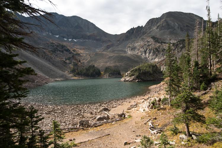
American Lakes and Lake Agnes trails, State Forest State Park

In northwest Colorado outside Walden, this state park has national park qualities. It’s no wonder why it’s come to be called “little Rocky Mountain National Park,” with moose-teeming wilds and alpine lakes spotting 70,000 acres under the gaze of the Medicine Bow and Never Summer mountains.
The trail options are plentiful and splendid. We offer American Lakes Trail as a longer option — “a great backpack trip,” the park calls it — with several side trips and a bonus to continue over Thunder Pass into Rocky Mountain National Park. Lake Agnes is more often visited; it’s perhaps the most photographed lake here with a peculiar, rocky island and view of the Nokhu Crags.


(1) comment
Great article
Thanx
Welcome to the discussion.
Log In
Keep it Clean. Please avoid obscene, vulgar, lewd, racist or sexually-oriented language.
PLEASE TURN OFF YOUR CAPS LOCK.
Don't Threaten. Threats of harming another person will not be tolerated.
Be Truthful. Don't knowingly lie about anyone or anything.
Be Nice. No racism, sexism or any sort of -ism that is degrading to another person.
Be Proactive. Use the 'Report' link on each comment to let us know of abusive posts.
Share with Us. We'd love to hear eyewitness accounts, the history behind an article.