


Presented by:

As the highest continuous paved road in the United States, Trail Ridge Road (US 34) offers visitors an array of Colorado views from the comfort of the car. Guests can see everything from aspen and ponderosa pine forests, subalpine forests, alpine tundra, wildflower meadows, and wildlife like marmots, ptarmigans, bighorn sheep and more on this 48-mile long route. Open to vehicle traffic around Memorial Day weekend in May to Columbus Day in October (weather dependent), Trail Ridge Road reaches a maximum elevation of 12,183 feet. Start your trip at the Grand Lake Visitor Center for maps, current road conditions, and wildlife viewing recommendations.
1. Farview Curve (10,148′ above sea level)

A view of the Never Summer Mountain Range from Trail Ridge Road in Rocky Mountain National Park. Photo Credit: Don Graham (flickr)
A little more than 16 miles from Grand Lake, you’ll find your first stop along Trail Ridge Road: Farview Curve. From this overlook, you can see the Kawuneeche Valley, Colorado River, and Never Summer Mountain Range. Keep your eyes open for elk roaming in the marshy valley. You may even be able to see “The Grand Ditch”, a scar on the side of the Never Summer Range. The Grand Ditch is evidence of a 1890 project to divert water to the eastern side of the mountain range. The ditch was completed in 1936 and now sends water over the Continental Divide to Colorado’s Eastern Plains.
2. Milner Pass and Poudre Lake (10,775′ above sea level)

Poudre Lake at Milner Pass in Rocky Mountain National Park off of Trail Ridge Road. Photo credit: Mark DeVries (flickr)
About 18.3 miles into your journey, you’ll cross the Continental Divide coming over Milner Pass. The water on the East side flows to the Mississippi River and the Atlantic Ocean, and the water on the West side flows to the Colorado River and the Pacific Ocean. Just east of the Divide is Poudre Lake, an alpine lake that is the main source of the Cache La Poudre River.
3. Medicine Bow Curve (11,640′ above sea level)

There are an abundance of elk in Rocky Mountain National Park. Photo Credit: blewulis (iStock)
About 22 miles in, you will hit the Medicine Bow Curve, a tight hairpin turn. Take in the Medicine Bow Mountain Range (now known as the Never Summer Mountains) and views of Wyoming to the North. See Mineral Point, Grand River Ditch, Baker and Howard Mountain, and Mt. Stratus, Red, Cumulus, Nimbus, and more to the west.
4. Alpine Visitor Center (11,799′ above sea level)

Alpine Visitor Center on Trail Ridge Road in Rocky Mountain National Park. Photo Credit: Tim Wilson (flickr)
You’re close to halfway at about 22.5 miles from Grand Lake! The Visitor Center is at the junction of Trail Ridge Road and Old Fall River Road. From the Visitor Center you have great views of the the alpine tundra and Fall River Cirque. Stop in for park information, to peruse the gift shop and book store, or to grab some food and a hot cocoa at the snack bar—the only restaurant in the park. The center is open seasonally.
5. Gore Range Overlook (12,048′ above sea level)

The Gore Range Overlook on Trail Ridge Road in Rocky Mountain National Park. Photo credit: adifferentbrian (flickr)
Travel about one mile down Trail Ridge Road from the Visitor Center to enjoy gorgeous views above treeline. The name says it all; overlook the Gore Range as well as the Never Summer Mountains to the west.
6. Lava Cliffs (12,135′ above sea level)

The Lava Cliffs on Trail Ridge Road in Rocky Mountain National Park. Photo credit: James St. John (flickr)
About 24.6 miles in, you’ll come to the Lava Cliffs, where you can see the evidence of the Rocky Mountain uplift that began almost 70 million years ago. In the Lava Cliffs, you can see faulting and Precambrian Rock as a result of the geologic activity.
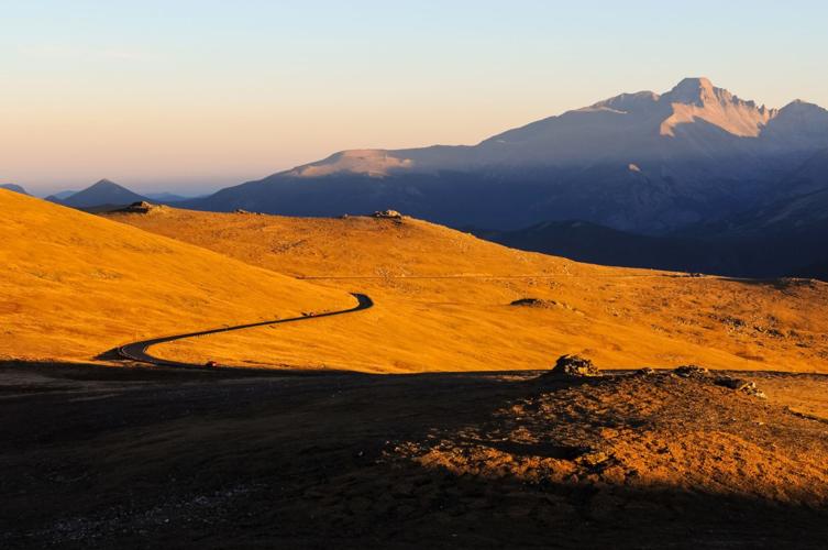
7. Rock Cut (12,178′ above sea level)

A panoramic evening view of Trail Ridge Road at Rock Cut, with Longs Peak (14,255 feet) rising high in the background, Rocky Mountain National Park, Colorado, USA. Photo credit: OutThere Colorado
You’ll reach one of the tallest points on Trail Ridge Road at mile marker 26.8. Rock Cut is a great spot to see open tundra and access the Toll Memorial Trail. Originally, Rock Cut obstructed travelers, but the completion of Trail Ridge Road in the summer of 1932 involved cutting the rock, so people could drive through.
8. Forest Canyon Overlook (11,758′ above sea level)

Forest Canyon Overlook on Trail Ridge Road in Rocky Mountain National Park. Photo credit: adifferentbrian (flickr)
Just before the 29-mile marker, you’ll come to the Forest Canyon Overlook. See the mountains along the Continental Divide and the lush green canopy in the canyon. The 0.2-mile walk from the parking lot along a paved path will also give you some of the best views in the state of Long’s Peak, Stones Peak, the icy blue Gorge Lakes, and Hayden Gorge.
9. Rainbow Curve (10,875′ above sea level)

Rainbow Curve on Trail Ridge Road. Photo credit: lawepw (flickr)
At 31.6 miles, you will reach Rainbow Curve where you can see Horseshoe Park, the Beaver Ponds, and the Alluvial Fan. In July of 1982, Lawn Lake broke through its terminal moraine, a natural dam. More than 29 million gallons of water carried trees and car-sized boulders down valley. The wash created a 42-acre alluvial fan, which you can see at this great overlook.
10. Many Parks Curve (9,691′ above sea level)

Many Parks Curve Overlook on Trail Ridge Road in Rocky Mountain National Park. Photo credit: adifferentbrian (flickr)
The Many Parks Curve is about 35.6 miles into your trip from Grand Lake. From the outlook, Deer Mountain and Long’s Peak stand tall against the mountainous landscape. Visitors can see the valleys sculpted millions of years ago by glaciers, and what today is known as Moraine, Horseshoe, and Estes Park.
11. Hidden Valley (9,325′ above sea level)

Hidden Valley on Trail Ridge Road in Rocky Mountain National Park. Photo credit: adifferentbrian (flickr)
Hidden Valley was a ski area developed in Rocky Mountain National Park in 1941. After years of controversy over an active business in the park, the area was closed in 1992. Now Hidden Valley is known as a great sledding place in the winter. Pull-off just after the 37.5-mile marker, to see the remnants of the hidden ski slopes. With a warming area and restrooms, it’s a handy spot to stop.
12. Deer Ridge Junction (8,978′ above sea level)

Trail Ridge Road connects Estes Park, on the eastern side of the park, with Grand Lake, on the western edge of the park. Photo credit: cumulus_humilis (iStock)
The final stop of your journey, Deer Ridge Junction, is about 40 miles into your trip. The East junction for US 36 and US 34, the Junction marks the ending of Trail Ridge Road to the East. From here, you can access Horseshoe Park, Upper Beaver Meadows, and Bear Lake Road.


(0) comments
Welcome to the discussion.
Log In
Keep it Clean. Please avoid obscene, vulgar, lewd, racist or sexually-oriented language.
PLEASE TURN OFF YOUR CAPS LOCK.
Don't Threaten. Threats of harming another person will not be tolerated.
Be Truthful. Don't knowingly lie about anyone or anything.
Be Nice. No racism, sexism or any sort of -ism that is degrading to another person.
Be Proactive. Use the 'Report' link on each comment to let us know of abusive posts.
Share with Us. We'd love to hear eyewitness accounts, the history behind an article.