


The presence of La Niña is strengthening as El Niño's grip on weather patterns continues to wane, according to an April update from climate researchers at the National Oceanic and Atmospheric Administration (NOAA).
NOAA Forecasters estimate there's an 85% chance El Niño will end later this spring and the tropical Pacific will transition to neutral conditions by the April–June period.
There’s also a 60% chance La Niña will develop by June–August and even higher by fall time, NOAA forecasters said.

NOAA Climate Prediction Center forecast for each of the three possible ENSO categories for the next 8 overlapping 3-month seasons. Blue bars show the chances of La Niña, gray bars the chances for neutral, and red bars the chances for El Niño.
"Overall, the forecast this month is very similar to last month, and we continue to expect (a) La Niña for the Northern Hemisphere fall and early winter — around an 85% chance," Emily Becker with the University of Miami/CIMAS said.
The La Niña and El Niño events are opposite phases of the El Niño-Southern Oscillation (ENOS) climate pattern and are responsible for varying weather effects in North America when they occur.
"Just like El Niño, La Niña changes the ocean and atmospheric circulation in the tropics," Becker said. "Those changes start in the Pacific Ocean and then ripple around the world in predictable ways."

2-year history of sea surface temperatures in the Niño-3.4 region of the tropical Pacific for all strong El Niño events since 1950 (gray lines) and the current event (purple line). Graph based on monthly Niño-3.4 index data from CPC using ERSSTv5.
Becker said El Niño’s peak from November–December 2023 was about 2.0° C or 3.6° F above neutral in the Niño-3.4 region of the tropical Pacific, but the anomaly has been dropping steadily and currently sits around 1.2° C, which it is still above the El Niño threshold of 0.5° C or 0.9° F.
The forecasters are continuously looking at the atmosphere over the tropical Pacific and found the El Niño pattern has mostly disappeared and is ending.
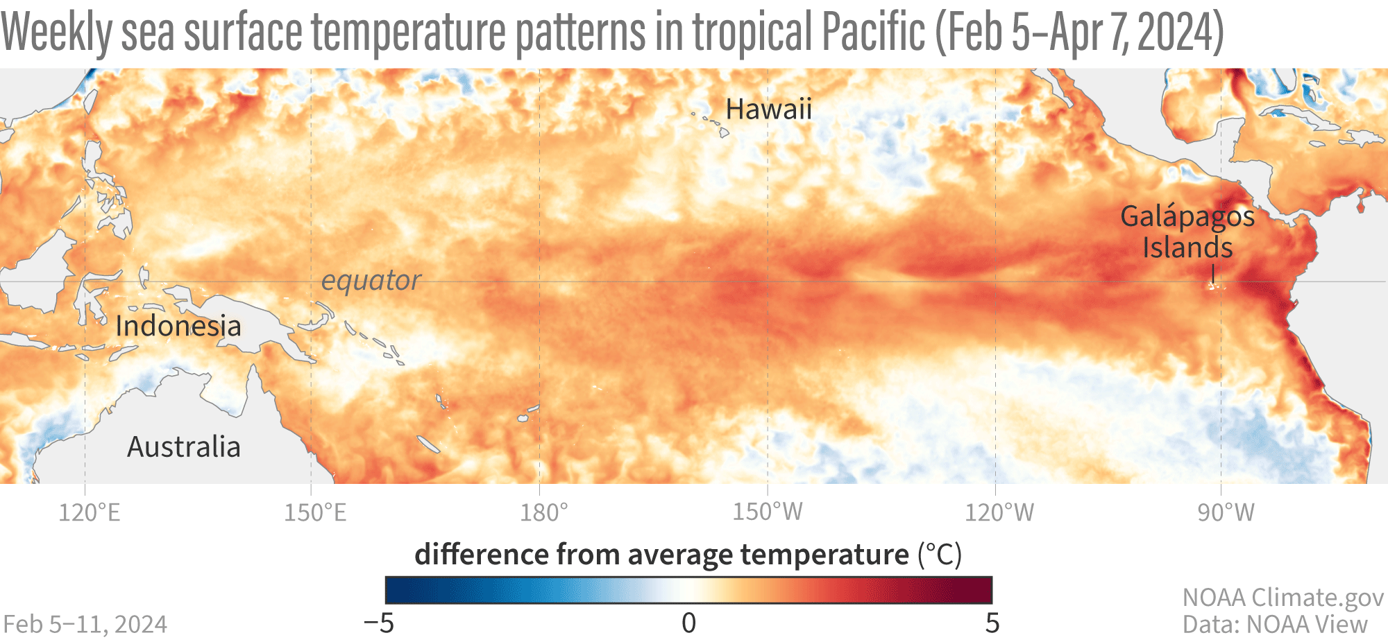
Animation of maps of sea surface temperatures in the Pacific Ocean compared to the long-term average over five-day periods from February through early April 2024. El Niño’s warm surface is weakening and some regions of cooler-than-average sea surface temperature are appearing.
Each week from Feb. 1-7 to April 1-7, waters off the west coast of South America along the equator have begun cooling and are forecast to reach ENOSO-neutral conditions by the April-June period.
"More evidence that El Niño is likely to give way to neutral soon, with La Niña right on its tail, can be found under the surface of the tropical Pacific," Becker said.
Becker said since January, two upwelling Kelvin waves — blobs of cooler water that travel from the west to the east under the sea's surface — have been moving through the equatorial waters and will continue to shift eastward and rise up, providing a source of cooler-than-average water to the surface.
What does La Niña mean for future weather through 2024?
One potential impact is that La Niña tends to create a more-active Atlantic hurricane season.
"It does this by reducing vertical wind shear — the change in wind from near the surface to high up in the atmosphere — over the Atlantic Ocean, making it easier for hurricanes to grow," Becker said.
Closer to Colorado and in western North America, La Niña tends to bring more snow to the northern states and northern Colorado during winter time as well as more likely odds to experience drought and intense heat during summer months.
"Some of the worst wildfires on record across California and the southwest have occurred during La Niña events, particularly in 2020 and 2021," according to Yale Climate Connections.org. "The U.S. Sun Belt is more likely to experience drought and intense heat during La Niña."
La Niña can also prolong warmer temperatures into fall, enhance wildfires and drought in the western states.
Looking long term in the Pacific's waters
Long-term warming of oceans is still an ongoing phenomenon.
According to Becker, El Niño’s warmer-than-average tropical Pacific tends to contribute to higher global average surface temperature, while La Niña’s cooler tropical Pacific usually contributes to 'relatively' cooler years.

This map from the National Center for Environmental Information shows where February 2024 temperatures fall in the 1951–2024 record. Record-warm February temperatures covered large areas of the Atlantic and Indian Oceans. Approximately 13.8% of the world's surface experienced record warm temperature this February, the highest percentage for February since the start of records in 1951.
"Emphasis is on the 'relative' since more recent La Niña events have been among the top ten warmest years ever," Becker said. "One can see that much of the global oceans are warmer than average, going beyond El Niño."
According to NOAA’s National Center for Environmental Information, “the February global surface temperature was 2.52° F or 1.40° C above the 20th-century average of 53.8° F or 12.1° C, making it the warmest February on record — dating back to 1850 — and the ninth consecutive month of record-high global temperatures.”

Monthly average temperatures (red dots and line) rose to more than 1.5 degrees Celsius above the pre-industrial average in late 2023. On average, forecasts from the North American Multi-model Ensemble (NMME) system indicate temperatures are likely to decline only slightly as El Niño continues to wane through early 2024. Graph based on data from NCEI and Emily Becker/IRI.
"We are just a few months in, and NCEI’s Global Annual Temperature Outlook already predicts 'a 45% chance that 2024 will rank as the warmest year on record and a 99% chance that it will rank in the top five',” Becker said.


(0) comments
Welcome to the discussion.
Log In
Keep it Clean. Please avoid obscene, vulgar, lewd, racist or sexually-oriented language.
PLEASE TURN OFF YOUR CAPS LOCK.
Don't Threaten. Threats of harming another person will not be tolerated.
Be Truthful. Don't knowingly lie about anyone or anything.
Be Nice. No racism, sexism or any sort of -ism that is degrading to another person.
Be Proactive. Use the 'Report' link on each comment to let us know of abusive posts.
Share with Us. We'd love to hear eyewitness accounts, the history behind an article.