
In the midst of North America’s largest alpine valley, an eternal struggle takes place.
A fluttering breeze drives sharp granules of sand along the same route they’ve traveled for millennia prior. Each season, the sand is pushed toward the top of a nearby mountain range, inching toward a ridge-line that if surpassed would release the sand into the great beyond.
But for most of the sand in this predictable wind, this freedom is never gained. After all, as predictable as the wind is the snow, and as predictable as the snow, the snowmelt.
And as the snow that annually amasses near the top of the aforementioned ridge-line starts to shift form, the sand encounters an obstacle that proves time and time again to be detrimental to its escape. First, in the form of a trickle and then in the form of a flow, the snow-turned-water heads downslope, dragging the fleeing granules of sand along with it.
Don’t feel bad for this sand though. It’ll get another chance to escape this perpetual cycle next year, and the year after that, and beyond.
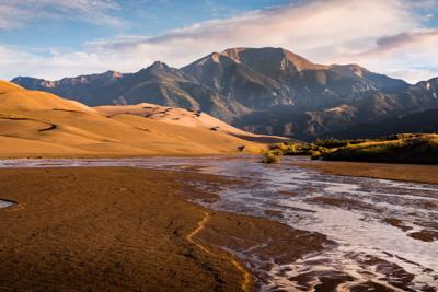
But until then, the sand will lie in wait with an incomprehensible number of its peers, dropped in a new spot in a familiar scene along the shores of Medano Creek at Colorado’s Great Sand Dunes National Park.
How the Dunes Were Formed
Nestled in the San Luis Valley, The Great Sand Dunes National Park is a spectacle that should hold a spot on every adventurer’s bucket list.
It’s here that dunes stretch toward the sky in waves, tucked beneath a bowl of often snow-capped mountain peaks that climb to more than 14,000 feet.
The dunes are odd. They seem out of place at their spot at the edge of a flatness that stretches toward a distant wall of mountains in every direction.
Satellite imagery reveals another insightful look at the terrain – the dunes a small pocket of ripples in a far corner of a vast space. From this bird’s eye-view, the San Luis Valley in its entirety is reminiscent of an ancient walled kingdom since decayed under the hazards of time.
The sight of the dunes in the valley begs curiosity regardless of the angle at which it is seen. How did something so spectacular and so unique end up here?
The search to find that answer seems to begin 26 million years ago, according to the United States Geological Survey. It’s always possible to go further back, but this is roughly when the Rio Grande Rift is thought to have occurred. In other words, this is when the earth’s crust in the area of now-Colorado and New Mexico started to pull apart, stretching in some places and rising in others.
As a result of the Rio Grande Rift, the San Luis Valley dropped as land around it arched upward, creating the mountains that still surround the valley today. Over the following millions of years, the landscape continued to change.
With a brief look at how the valley was formed, let’s fast forward to the Pliocene Epoch, approximately 2.6 to 5.3 million years ago.
One result of the Rio Grande Rift and the creation of the San Luis Valley was that a large basin with very limited drainage was created.
With no drainage from the valley, water in the valley was left to collect… and it wasn’t just water that collected. All of the sediment left behind from a changing landscape was collected, as well, drawn to the valley floor with the water that was filling the space.
According to the United States Geological Survey, this is when a lake, now dubbed Lake Alamosa, occupied a majority of the San Luis Valley thanks to all of this trapped moisture. This lake filled a large portion of the valley floor for quite some time, up through the Middle Pleistocene period, which is estimated at 126,000 to 781,000 years ago.
Throughout the time the lake was present, it grew and shrunk, moving sediment around the valley with each change.
This happened for thousands of years while the lake dominated much of the valley, and then seemingly suddenly, this changed.
Water started to overfill a section in the southern area of the valley. As this overflow took place, the moving water cut a deep gorge in a wall of volcanic rock. As this cut got deeper, water continued to drain, eventually forming the Rio Grande River to the south of Colorado.
This started to dry the valley out. And then came the most recent ice age.
It’s believed that this most recent ice age is when the dunes started to form.
Winds are said to have pushed the sediment collected by the now-missing Lake Alamosa toward the mountains. These winds were consistent, predictably blowing from the southwest. As the wind blew this sand over time, the sand was collected within a natural pocket of the mountains on the northeast edge of the valley, according to the National Parks Service.
While the winds were consistent in behavior, they didn’t always blow the same direction depending on the weather. During storms, the winds actually flip to blow back down toward the valley, thus this is how the sand dunes gained their height – the opposing winds.
While these winds are quite powerful when it comes to moving sand back toward the dunes at lower elevations in the valley, there’s a different process in place for sand that makes it further up the mountainside. This is where the famous Medano Creek comes in.
Each year, as the snow that’s accumulated on top of the surrounding mountain peaks starts to melt, it forms two streams – Medano Creek and Sand Creek. As these creeks form from a number of trickles, they inadvertently collect sand that has been trapped on rocky slopes, bringing it back down to the valley floor to soon be blown back into the dunes.
Seeing the Creek
Of the two creeks, Medano is the most notable, cutting a route directly around the most scenic edge of the dunes, just hundreds of feet from the Visitor’s Center.
Granted, depending on the time you plan your visit, it’s possible to stop by the dunes and not realize that the seasonal Medano Creek exists at all. Because this creek relies on snowmelt to flow, it’s only visible when snowmelt is occurring.
Medano Creek typically appears in late-April on the average year before peaking in late-May. It then tends to drop in flow throughout June until it disappears completely in July.
Though this means that visitors are quite limited on when they can visit if they’re looking to see the creek, it’s also worth noting that this is no typical creek.
Though shallow, typically no more than a few inches in most spots, Medano Creek can become quite wide. During heavy periods of flow, the creek can stretch 100s of feet across, flanked by sandy banks. While the creek is at its peak, it becomes a popular spot for outdoor recreation, attracting thousands of tubers and beach-goers from around the state.
The annual peak flow of Medano Creek tends to fall somewhere around 40 cubic feet of water per second, or in other words, the equivalent of 40 “basketballs” worth of water rolling by a fixed point each second. Keep in mind that this compares to average peak flows in the low-thousands on most of Colorado’s rivers. For instance, the nearby Arkansas River can average 2,200 cubic feet per second throughout June, its typical peak month.
Why Does Medano Creek Surge?
Another noteworthy aspect of Medano Creek is a phenomenon called a “surge-flow.” Because the creek runs over sand, the water flow is constantly impacted by a changing creek bed. With the flowing water, underwater ridges of sand build up, trapping water, but quickly breaking. According to the National Parks Service, these ridges break quite frequently, releasing surges of waves occur every 20 seconds, sending a wall of water double or triple the average depth down the creek.
A sight that makes an already spectacular scene more spectacular, it’s worth planning your trip to the Sand Dunes around seeing Medano Creek, as well.
Are the Dunes Changing?
According to the National Parks Service, the snowmelt’s ability to recycle escaping sand via Medano Creek and Sand Creek is one of three reasons the dunes were able to form in this pocket of the San Luis Valley in the first place. The other two factors are the presence of opposing winds that add height to the dunes and the massive amount of sand and sediment left behind from the former Lake Alamosa.
The sand’s presence initially allowed for the dunes to form, the wind did the shaping over time, and the snowmelt ensures that the dunes will last.
Today, the dunes seem to have reached a state of stability. Comparisons of photographs taken of the dunes over the years reveal nearly identical lines of sand, even when making comparisons between now and when the dunes were first photographed in the mid-1800s.
According to the National Parks Service, this lack of change will likely persist and is due to a couple different factors.
First, there’s a good amount of vegetation on the valley floor today. This adds a layer of friction to the movement of the sand, preventing the sand from blowing around too much. Second, the dunes remain relatively moist. While visitors walk on a few inches of dry, loose sand, the sand that lies just beneath this remains wet and is too heavy to be blown and shaped by the wind.
Not Always the Case
Oddly enough, this lack of change is not always the case. There is still some movement of sand around the valley in the form of parabolic dunes. Put simply, these dunes can form when vegetation is removed from a sandy space. Wind blows this newly released sand into tiny dunes that are able to slowly plow their way through the terrain over time, possibly far enough to join the distant larger dunes in some cases.
In Closing
A scene of grandeur, the Great Sand Dunes National Park will be a natural destination that continues to mystify for decades to come. Realizing that it’s the culmination of many pieces falling into place over the course of millions of years only makes it that much more spectacular.
The next time you find yourself in this corner of the world, remember the geological history of the ground you’re standing on. Feel the wind that carries the sand time and time again. Look up to admire the peaks that trap it, performing the same silent duty that they have for millennia. Imagine a lake filling the space and consider the time it took for that lake to slowly grind down a narrow gap in the surrounding wall of mountains, draining to create the seemingly dry landscape that exists today.
And before you leave the dunes, stop and listen. If you’re lucky, you might hear the sand sing.
It’s a sound that’s more of a low-pitched groan than something you’d hear on the top 40 charts, but if you’re in the right spot and listening closely, it’s there.
This sound occurs when sections of dunes start sliding, likened to a mini-avalanche. These slides can occur during periods of strong winds and storms or when someone gives the sand a little push.
Go ahead, give the sand a push. Listen as compression squeezes the air out of sand in motion and know that even though you gave that sand a push down the dune, in the grand scheme, it won’t matter.
That sand will likely travel from the spot it lands to the next dune, and then over that and to the next, until it reaches the edge of the dune field, leaving it behind for the nearby mountainside. But it won’t be there for long. Eventually, winter will come, and with it, the snow, and that will be followed by the spring, and with it, the snowmelt. And as the snowmelt fills Medano Creek, it will bring that sand back with it, replenishing the supply of the dunes in a time-tested natural way that will likely continue long after the generations of today are long gone.


(0) comments
Welcome to the discussion.
Log In
Keep it Clean. Please avoid obscene, vulgar, lewd, racist or sexually-oriented language.
PLEASE TURN OFF YOUR CAPS LOCK.
Don't Threaten. Threats of harming another person will not be tolerated.
Be Truthful. Don't knowingly lie about anyone or anything.
Be Nice. No racism, sexism or any sort of -ism that is degrading to another person.
Be Proactive. Use the 'Report' link on each comment to let us know of abusive posts.
Share with Us. We'd love to hear eyewitness accounts, the history behind an article.