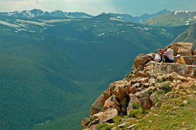
Forest Canyon Overlook offers some of Trail Ridge Road’s most dramatic views. The 11,716-foot viewpoint perches on the eastern edge of Forest Canyon, a deep U-shaped valley in the heart of Rocky Mountain National Park. Glaciers chiseled out the deep canyon along a major fault line that the Big Thompson River now follows. The Continental Divide, the spine that separates the Atlantic and Pacific watersheds, hangs on the skyline across the valley. Its high peaks include Mount Ida, Terra Tomah Mountain, and Sprague Mountain, while iconic 14,259-foot Longs Peak is to the south. The 33-car parking lot is on the west side of Trail Ridge Road, 6.2 miles from Alpine Visitor Center and 16.8 miles from Beaver Meadows Visitor Center. A paved 0.2-mile, handicap-accessible trail goes west to the overlook. Interpretative signs are along the trail and at the viewpoint, explaining geology and the tundra. Stay on the trail to avoid damaging fragile alpine vegetation.
Pro Tips
Trail Ridge Road, the highest continuous auto road in the United States, travels 45 miles over Trail Ridge in Rocky Mountain National Park. The road runs above 12,000 feet for four miles and over 11,000 feet for 11 miles. It climbs almost 5,000 vertical feet from Estes Park to its high point, traveling through three life zones that’s the equivalent of traveling from Colorado to the Arctic. The high grassy ridge has a severe climate with a short summer and over 40 inches of annual precipitation.Be sure to stop at other overlooks along Trail Ridge for marvelous views. Many Parks Curve and Rainbow Curve overlooks yield great views of Horseshoe Park, Moraine Park, and Estes Park. Rock Cut Overlook, two miles north of Forest Canyon Overlook, has views of the Continental Divide and Longs Peak. Gore Range Overlook gives views of the distant Gore Range and the nearby Never Summer Range. Below Fall River Pass are Milner Pass and the headwaters of the Cache la Poudre River and Farview Curve Overlook, which gazes down the Kawuneeche Valley.Park at Rock Cut Overlook and take a hike on the out-and-back, 0.5-mile Tundra World Toll Memorial Trail, which gives a great introduction to the plants and wildflowers in this land above the trees. The paved wheelchair-accessible trail climbs to 12,304 feet across open tundra to Mushroom Rocks, views of Longs Peak and the Mummy Range, and has lots of wildlife including elk and marmots. The round-trip hike is one mile and takes about half an hour.The Alpine Visitor Center at 11,796 feet on Fall River Pass is the highest national park visitor center in the United States. The center has scenic views of the Fall River cirque, educational displays about the alpine tundra ecosystem and geology, park information, a ranger-staffed desk to answer your questions, a bookstore, and food and drink at the Trail Ridge Store and Café.Recommended season(s): Year-round.
—Stewart M. Green


(0) comments
Welcome to the discussion.
Log In
Keep it Clean. Please avoid obscene, vulgar, lewd, racist or sexually-oriented language.
PLEASE TURN OFF YOUR CAPS LOCK.
Don't Threaten. Threats of harming another person will not be tolerated.
Be Truthful. Don't knowingly lie about anyone or anything.
Be Nice. No racism, sexism or any sort of -ism that is degrading to another person.
Be Proactive. Use the 'Report' link on each comment to let us know of abusive posts.
Share with Us. We'd love to hear eyewitness accounts, the history behind an article.