


Days after the popular Keyhole Route on 14,259-foot Longs Peak was shut down for the recovery of a body, additional information has been released about what led up to the deadly incident in Rocky Mountain National Park.
Park officials have since identified the deceased person as Russell Jacobs, 25 and of Westminster. Jacobs was on Longs Peak on Friday late afternoon when he contacted a friend via a cellular device, reporting that he was lost and that weather was rapidly deteriorating. Jacobs didn't have the right gear for winter conditions, nor was he prepared to spend the night at an elevation of 13,000 feet.
This information was ultimately relayed to park rangers, who were able to contact Jacobs via text, ascertaining his location and his plan to move toward the Anges Vaille Shelter. This is a stone shelter that's found along the Keyhole Route at about 13,400 feet of elevation, above a section known as the 'Boulder Field.'

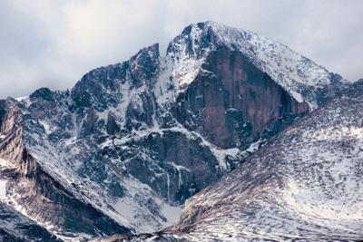
File photo. The Agnes Vaille Shelter can be seen in this image, to the left of the namesake 'Keyhole' notch on the ridgeline. It's fairly camouflaged, so it might take a second to spot. Climbers on this route move up this scree field, past the shelter, and through the notch to the other side of the ridge while on their way to the summit. Photo Credit: Douglas Rissing (iStock).
After determining that Jacobs was headed to this shelter near the top of the peak, communication with him was lost.
Members of the park's search and rescue team started their search of the Boulder Field and Keyhole areas of the route on Friday afternoon. Harsh weather made the search difficult, amid 35 mile per hour winds, accumulating snow, and below freezing temperatures. Crews reached the Anges Vaille Shelter, but could not locate Jacobs.

A image taken during the search and rescue mission related to this fatal incident. Photo Courtesy: Rocky Mountain National Park.
Crews sheltered in the Boulder Field area overnight, as snow and sleet continued to fall. With no sign of Jacobs, crews continued their searching prior to sunrise the next morning.

A image taken during the search and rescue mission related to this fatal incident. Photo Courtesy: Rocky Mountain National Park.
Jacobs' body was found by another hiker on Saturday, roughly 80 feet above the 'Ledges' section of the route. The person who discovered Jacobs' body described conditions in the area as icy. That man's party was reportedly able to flag down a search helicopter in the area and Jacobs' body was recovered the following day. No information on cause of death has been released.
The 'Ledges' section where Jacobs was found is located just past the namesake Keyhole notch, consisting of ledges flanked by a cliff. Painted marks on the rock are used to help hikers navigate this section, meaning snow and darkness can make this portion of the route much more difficult to follow than it would be in favorable conditions. Getting off-route in this area can put hikers into much more dangerous terrain.
Longs Peak is a mountain that's notorious for bad weather. The final push to the summit is a long, slow scramble that means quite a bit of commitment, with weather on much of the peak hidden from hikers until they pass through the Keyhole notch. In total, the Longs Peak route is about 14.5 miles long with about 5,100 feet of vertical gain. It's worth noting that a large portion of the climb is very rocky terrain with class three moves, which can be more physically taxing on the body than a simple trail and can make slick conditions and icy rocks major concerns. Several high-elevation sections are also very exposed. This route should not be taken lightly.
Condolences go out to those impacted by this death.
When entering high elevation terrain during this time of the year in Colorado, it is crucial to be aware of changing forecasts. Additional layers of clothing and traction aids, such as shoe spikes, should be included in a hiking kit.
STAY INFORMED: Sign-up for the daily OutThere Colorado newsletter here


(0) comments
Welcome to the discussion.
Log In
Keep it Clean. Please avoid obscene, vulgar, lewd, racist or sexually-oriented language.
PLEASE TURN OFF YOUR CAPS LOCK.
Don't Threaten. Threats of harming another person will not be tolerated.
Be Truthful. Don't knowingly lie about anyone or anything.
Be Nice. No racism, sexism or any sort of -ism that is degrading to another person.
Be Proactive. Use the 'Report' link on each comment to let us know of abusive posts.
Share with Us. We'd love to hear eyewitness accounts, the history behind an article.