
Flash flooding, landspout tornadoes, and large hail are among the collection of Wednesday weather hazards found on Colorado's Front Range.
The National Weather Service has issued a warning of life threatening flash flooding that will be occurring in the Colorado Springs area and beyond. Heavy rain continues with more than an inch of rain already falling by 4:14 PM. The warning is currently active until 7:15 PM.
The impacted area includes the following places: Colorado Springs, Fountain, Manitou Springs, Stratmoor, Fort Carson, Security, Peterson AFB, Security-Widefield and Cimarron Hills.
The statement warns motorists about crossing flooded roads with the phrase "turn around, don't drown." Most flood deaths happen in vehicles.
Find the most up-to-date information on the National Weather Service website.
Another risk is tennis ball-sized hail. See the impacted area of this warning in the tweet below.
Severe Thunderstorm Warning continues for Security CO, Fountain CO until 5:00 PM MDT pic.twitter.com/YZT6BWCAyj
— NWS Pueblo (@NWSPueblo) August 5, 2020
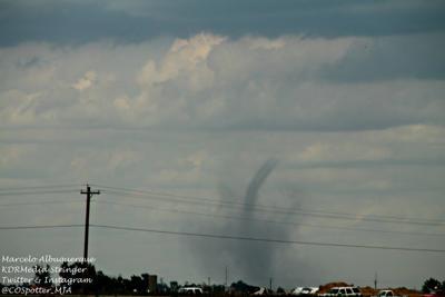
Landspout tornados have also been spotted east of Denver with the possibility of more on the way.
We have received a few reports of brief landspout tornadoes to the east of Denver within the last hour. More landspout tornadoes are possible through the rest of the afternoon. #COwx pic.twitter.com/2WYOHDYPEW
— NWS Boulder (@NWSBoulder) August 5, 2020
This is a developing story.


(0) comments
Welcome to the discussion.
Log In
Keep it Clean. Please avoid obscene, vulgar, lewd, racist or sexually-oriented language.
PLEASE TURN OFF YOUR CAPS LOCK.
Don't Threaten. Threats of harming another person will not be tolerated.
Be Truthful. Don't knowingly lie about anyone or anything.
Be Nice. No racism, sexism or any sort of -ism that is degrading to another person.
Be Proactive. Use the 'Report' link on each comment to let us know of abusive posts.
Share with Us. We'd love to hear eyewitness accounts, the history behind an article.