
Flash flooding and strong storms are likely in parts of Colorado Saturday, which are likely to disrupt travel and outdoor activities this weekend, according to the National Weather Service.
Between 1 p.m. and 9 p.m. Saturday, isolated strong storms and flash flooding are highly likely for central Colorado, including Colorado Springs, Pueblo, Canon City, Buena Vista, Westcliffe, Woodland Park, and other areas. Travel on the Interstate 25 U.S. Highway 50 corridors could be impacted.
Click here for Colorado Department of Transportation's Travel Center for updated road conditions and closures throughout the state.
RELATED: Multiple major road closures in Colorado mountains due to mudslides
RELATED: Search continues for 3 missing after deadly flash flooding in Colorado canyon
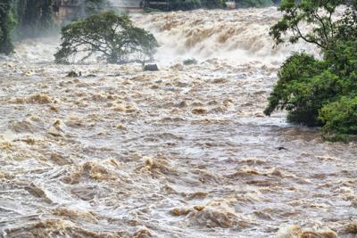
Wind gusts up to 55 mph, nickel-size hail, and flash flooding are expected in the storms, the weather service said.
At 2:21 p.m., local law enforcement reported heavy rain in Pinon and northern Pueblo West area, according to a Flash Flood Warning issued by the weather service. Between 1 and 3 inches of rain have fallen. Authorities and trained weather spotters report up to 1.5 feet of water in the Purcell and I-25 underpass, the warning said.
The expected rainfall rate is 1 to 2 inches in 1 hour. An additional 1.5 inches of rain is expected, meteorologists say. Flash flooding is already occurring.
The Flash Flood Warning is issued for north and central Pueblo County until 4:45 p.m. Saturday.
For mountains west of the Front Range, including Chaffee County and Fremont County, a Flash Flood Watch is issued until 9 p.m. Saturday. The warning reports slow moving thunderstorms that are capable of producing locally heavy rain and flash flooding. Rock slides and quick rises in creeks and streams will be possible. Mud and debris flows will be possible in and near burn scars.
For northeast and north central Colorado, cooler and drier air has moved into the area which will limit shower and storm activity Saturday. The best chance for storms will be in Park County and along the southern foothills and Palmer Divide with heavy rain and lightning being the primary threats.


(0) comments
Welcome to the discussion.
Log In
Keep it Clean. Please avoid obscene, vulgar, lewd, racist or sexually-oriented language.
PLEASE TURN OFF YOUR CAPS LOCK.
Don't Threaten. Threats of harming another person will not be tolerated.
Be Truthful. Don't knowingly lie about anyone or anything.
Be Nice. No racism, sexism or any sort of -ism that is degrading to another person.
Be Proactive. Use the 'Report' link on each comment to let us know of abusive posts.
Share with Us. We'd love to hear eyewitness accounts, the history behind an article.