
Seventeen counties along the Front Range and across eastern plains in Colorado have been issued a tornado watch by the National Weather Service Sunday, following the previous day's active weather that produced nine tornados and one funnel cloud in those areas.
The following counties are under a tornado watch as of about 12:30 PM:
Adams, Arapahoe, Cheyenne, Crowley, Denver, Elbert, El Paso, Kiowa, Kit Carson, Lincoln, Logan, Morgan, Phillips, Sedgwick, Washington, Weld, and Yuma. The tornado watch is set to expire at 8 PM Sunday at time of publishing.
A tornado warning issued by the weather service described the weather as a "particularly dangerous situation" for northeast Colorado, specifically for the towns of Iliff, Crook, and Proctor until 4:30 PM.
THIS IS A PARTICULARLY DANGEROUS SITUATION!!!TAKE COVER IF IN THIS WARNING!!!SEEK SAFE SHELTER NOW - LOWEST FLOOR OF YOUR HOME OR BUSINESS!!! #COwx https://t.co/NgWnTIbN6B
— NWS Boulder (@NWSBoulder) May 23, 2021
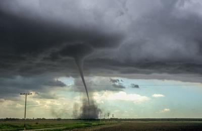
The cone tornado was reportedly confirmed by storm chasers and has reached the ground.
A PDS (Particularly Dangerous Situation) #Tornado warning has been issued for this storm near Ilif, #Colorado. A fairly large cone tornado has been confirmed to be on the ground by storm spotters. If you live in the path of this dangerous storm, take shelter now. #weather pic.twitter.com/9aD9lqbPNF
— Weather and Climatology (@AndClimatology) May 23, 2021
Crazy light show w/ this line of storms! More than 900 strikes in the past 20 min! #9WX pic.twitter.com/RMU4O1oLpP
— Danielle Grant (@theWXwoman) May 23, 2021
Large hail and damaging winds and continuous cloud to ground lightning is reported from this storm. During severe weather, meteorologists warn those in the proximity to storms should move to an interior room on the lowest floor of a building.
[WATCH] 9 tornadoes reported in plains of eastern Colorado
Trained spotter reports funnel cloud near Truckton with this tornado warned storm #cowx pic.twitter.com/W2Yq5V62Ao
— Valerie Mills (@ValWeatherGal) May 23, 2021
Tornado Watch has just been issued for western Nebraska and eastern Colorado until 8pm. Denver is included, as well as parts of Wyoming and Kansas. More details on WeatherNationTV pic.twitter.com/YEhfo18mTh
— WeatherNation (@WeatherNation) May 23, 2021
A severe thunderstorm warning is issued for southeastern El Paso County and north Pueblo County until 12:45 PM Sunday.
At 12:11 PM, a severe thunderstorm was located 11 miles northeast of Pueblo, moving northeast at 55 mph, the weather service reports. Wind gusts of 60 mph and quarter-sized hail were detected. Meteorologists warn the hail is likely to cause damage to vehicles, as well as wind damage to roofs, siding, and trees.
TORNADO WARNING: Very dangerous storm over se El Paso and ne Pueblo counties. Seek shelter and stay up to date as we track this storm @FOX21News pic.twitter.com/R0S4lS4bna
— Valerie Mills (@ValWeatherGal) May 23, 2021
Central and eastern areas of Colorado can expect more active weather Sunday, including isolated tornadoes, golf ball-sized hail, and damaging winds. Read an updated forecast for Sunday here.


(0) comments
Welcome to the discussion.
Log In
Keep it Clean. Please avoid obscene, vulgar, lewd, racist or sexually-oriented language.
PLEASE TURN OFF YOUR CAPS LOCK.
Don't Threaten. Threats of harming another person will not be tolerated.
Be Truthful. Don't knowingly lie about anyone or anything.
Be Nice. No racism, sexism or any sort of -ism that is degrading to another person.
Be Proactive. Use the 'Report' link on each comment to let us know of abusive posts.
Share with Us. We'd love to hear eyewitness accounts, the history behind an article.