


Though much of Colorado’s landscape was shaped by volcanic activity, only one volcano remains active in the Centennial State – Dotsero volcano. Technically, it’s dormant at the moment, which means it’s active yet not erupting, but could erupt again.
Last erupting roughly 4,150 years ago, the Dotsero volcano is still a long way from the 10,000 years of inactivity required to deem a volcano extinct.
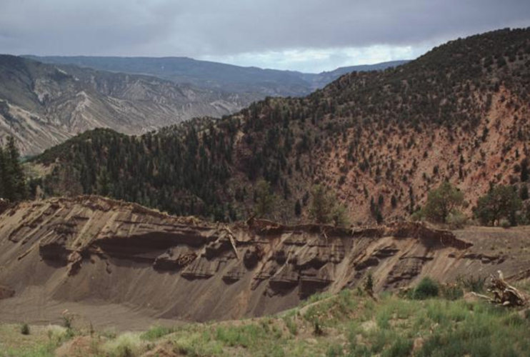
Located in northwest Colorado near a small town of the same name – Dotsero – and the junction where the Colorado and Eagle rivers meet, Dotsero Volcano is quite accessible. It’s found just off of I-70, which actually cuts across part of the hardened lava that came with its last eruption. This lava flow stretches 3 kilometers and is said to be visible on the south side of the interstate, with the volcanic crater positioned on the northern side.

Here’s an aerial view that shows where Dotsero Crater is in relation to I-70. Note the circle shape around the pin drop. Photo Credit: @2019 Google Maps.
Here’s a zoomed in look at the shape of the crater.

This zoomed aerial image gives a better look at the shape of Dotsero Crater. Photo Credit: @2019 Google Maps.
The most visible evidence of the Dotsero volcano comes in the form of a maar – a fancy word for the crater that gets left behind following a volcanic explosion. According to the USGS, this explosion occurred when magma beneath the earth encountered water. This resulted in a blast that would create a crater with a 2,460-foot diameter and a depth estimated to be 1,300 feet. Today, the depth is only around 250 feet, filled with debris over time.
When it comes to the question of whether or not Dotsero could erupt again, the USGS seems to think there’s a chance. The threat level of Dotsero is currently ranked in the “ moderate” category, which means that it requires real-time monitoring.
A 2005 article published by the Post Independent expands on this answer, stating that the real threat of an eruption would be ash spewed into the air, disrupting air travel and planes in flight. It goes on to state that the volcano is unlikely to erupt within the lifetime of anyone currently alive.
Getting there
If you want to visit this spot, you can. The GPS coordinates for the Dotsero maar are 39.663º N, 107.032º W at an elevation of 7,316 feet. To reach the Doterso Crater Recreation Site, you’ll take the Dotsero exit (Exit 133) on I-70, traveling east along the highway access road until you each road 8460. At this point, you’ll drive north until you find the recreation site. It’s not much of a hike, but it’s a cool site to see. Find more information here or here.
Editor’s Note: This spot could be subject to closures. Check with an official resource to determine if access is open or if any sort of seasonal closure is in place.


(0) comments
Welcome to the discussion.
Log In
Keep it Clean. Please avoid obscene, vulgar, lewd, racist or sexually-oriented language.
PLEASE TURN OFF YOUR CAPS LOCK.
Don't Threaten. Threats of harming another person will not be tolerated.
Be Truthful. Don't knowingly lie about anyone or anything.
Be Nice. No racism, sexism or any sort of -ism that is degrading to another person.
Be Proactive. Use the 'Report' link on each comment to let us know of abusive posts.
Share with Us. We'd love to hear eyewitness accounts, the history behind an article.