


As drivers new to Colorado's roads quickly learn, some routes are simply 'more dangerous' in this state. That's hard to say about most places around the country, where a road is a road and the most dangerous hazards encountered are other drivers.
That's not the case in Colorado – there's treacherous weather to watch out for, steep grades that burn out brake pads, cliff drops that inch too close along narrow lanes, and more.
In my opinion (and in no specific order), here are nine of the 'most dangerous' roads in Colorado. Each selected for a certain reason, all of these roads have proven dangerous in recent years.
1. Black Bear Pass
Black Bear Pass is notoriously billed as the 'most dangerous' road in Colorado and that's a claim that's hard to argue.

Black Bear Road, Telluride, Colorado. Photo Credit: Dave Williams
Found just outside the town of Telluride, Black Bear Pass includes a one-way downhill-only stretch of narrow and exposed switchbacks. Because of this, the drive should be reserved for only the most experienced rock crawlers who also happen to be operating a vehicle made for the job.
People have died on this road and rollover crashes are not a rarity. Even those hiking the most extreme stretch call it daunting, with the steep grade of the route opening up stunning, but intimidating views.
This road should not be taken lightly.
2. Mount Evans Scenic Byway
A road known for attracting plenty of tourists, the Mount Evans Scenic Byway also features massive cliff drops. The road that travels along those cliff drops is narrow, with one lane traveling in each direction. And the lane that's closest to the cliff – it's got strange undulations and is a bit crumbly in spots. Also, there aren't guardrails and drivers should be on the lookout for wildlife and inclement weather typical to the wild storms found at 14,000 feet above sea level. Scared yet?

Mount Evans Scenic Byway. Photo Credit: Betty4240 (iStock).
Billed as one of the state's best tourist attractions (I'd agree), I'm sure plenty of flatlanders have reconsidered their decision to travel Mount Evans Scenic Byway in the rental car they picked up from DIA. After all, it does travel to an elevation of 14,130 feet!
This road can be a white-knuckled shocker for those familiar and unfamiliar with mountain driving, alike.
During the COVID-19 pandemic, Mount Evans Scenic Byway was shut down for a period of time for repairs. Some of these repairs likely addressed a few of the issues with the road (and I haven't been up there since). That being said, things that can't be changed – the exposure, coupled with number of inexperienced mountain drivers the road attracts – keep this one on my 'dangerous drives' list.
Thankfully, it shuts down when winter conditions hit.
Side note – Pikes Peak, in Colorado Springs, is another 14,000-foot mountain with a road that reaches the summit. There's also exposure on this route, but it's another option to look into. It's a bit more commercialized and I would say that the road feels a bit safer to drive compared to Mount Evans Scenic Byway. Both are worth checking out.
3. Monarch Pass
Any road that's at risk of getting hit with an avalanche probably deserves a spot on this list, including Monarch Pass, near Salida.

A landscape shot of the Madonna Mine, located just below the top of Monarch Pass in the Sawatch Range of the Rocky Mountains of Colorado. This image shows how steep the drop off the pass is. Photo Credit: chapin31 (iStock).
Not only is this steep and winding road shut down at some point each year due to avalanche risk or because an avalanche has actually hit the road, exposure and wildlife are also factors that can make the route dangerous. In the summer, rock fall risk is also something to watch out for.
4. Independence Pass
Some call the Independence Pass drive the most beautiful route in Colorado while others drive it once and swear they never will again.

A higher point of Independence Pass. Photo Credit: krblokhin (iStock).
In reality, Independence Pass, connecting Aspen to Twin Lakes, is mostly the same as any other paved mountain pass in Colorado in terms of safety. That being said, there is one stretch of road that tends to freak people out, particularly narrow and with quite a bit of exposure. Driving that stretch means respecting a fine balance between the center line and the edge of the pavement.
It's no surprise this road gets shut down during the winter – it does reach an elevation of 12,095 feet.
5. The Million Dollar Highway
Perhaps the most notorious route on this list, the 'Million Dollar Highway,' also known as Red Mountain Pass or Highway 550, is a stretch of road that travels between the San Juan Mountain Range towns of Ouray and Silverton. About 25 miles long, this road cuts off hours of driving time between the two towns, with the Colorado Department of Transportation often hard at work to keep it open through as much of winter as possible.

Red Mountain Pass is along the Million Dollar Highway in Southwest Colorado. It's one of the state's most spectacular routes, but also one of the most treacherous, with grades as steep as 8%. Proceed with caution. Photo Credit: Adventure_Photo (iStock).
Not only can icy and snowy conditions impact the safety of the road, massive cliff drops flank one side of the route as it winds its narrow route through a stunning valley. Don't expect many guardrails on this one, either.
In the summer, rock fall risk is also a concern on this stretch of road. Proceed with caution.
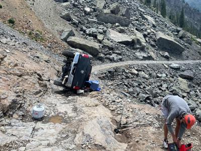
6. Lake Como Road
Most people exploring Colorado will never find themselves on Lake Como Road – and that's probably a good thing. Those that do end up in this neck of the woods better have a very capable off-road vehicle with skills to match or be on foot.

One of the obstacles found along Lake Como road. Note how the road travels over this rocky section, which is much more intimidating in person. A steep slope is found on the left. Photo Credit: Spencer McKee.
Lake Como Road is found in the San Luis Valley, leading to Lake Como and several fourteeners of the Sangre de Cristo mountain range – including Little Bear Peak.
Massive rock obstacles along the road prevent almost every vehicle from reaching the alpine basin above, with death and serious injury both proven risks of traveling the route.
Plus, the extreme and narrow nature of the road may make a vehicle recovery very difficult. If you get your ride damaged or stuck, it might be stuck there for awhile.
While this road leads to a beautiful place, most should stick to other routes that don't mean a potential life-or-death scenario, an expensive vehicle repair, or a 12-mile dirt road walk. Travelers beware.
7. I-70 through Glenwood Canyon
It's hard to pull together this list of dangerous roads without including the Glenwood Canyon stretch of I-70 due to a number of recent safety-related shutdowns.
Following the destructive Grizzly Creek Fire that tore through the surrounding area, the burn scar left behind has resulted in flooding and mudslides along this stretch of interstate.

FILE PHOTO: A mudslide stretches across I-70 through Glenwood Canyon in 2021.
Last year, mudslides or mudslide risk caused numerous closures, with debris hitting vehicles in at least one case and stranding people in another.
The Colorado Department of Transportation is likely to put a safety closure in place if a risk is present, but the unpredictable nature of life in Colorado remains at bay.
Be on the lookout for possible travel alerts when on this stretch of road.
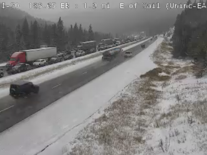
8. Vail Pass
Come winter months, there always seems to be an accident on Vail Pass. While this road is a paved, multi-lane stretch of pristine Colorado highway, it still seems to attract its fair share of problems. It's likely due to its high elevation of 10,666 feet, its steep grade of 7 percent at times, and the number of ski tourists that travel the road – some of whom may be unfamiliar with snow or mountain driving.

Traffic backed up in the area of Vail Pass on westbound lanes of I-70. Photo Credit: CDOT.
Something similar could be said for many mountain highways around the state, particularly the I-70 corridor. Snow and other weather extremes can make dangerous roads much more dangerous, fast. Always be prepared for a potential closure when traveling Colorado's mountains in the winter.
9. I-25 between Denver and Colorado Springs
Roll your eyes at me if you want, but the stretch of I-25 between Colorado Springs and Denver becomes a major hazard when winter weather hits. Hundreds of people have been stranded on this road before amid snowy, whiteout conditions and the amount of people that use this route seems to amplify any issue.

A snow plow passes an abandoned car on I-25 near the Greenland exit north of Colorado Springs Monday, February 1, 2016. (Mark Reis, Gazette file)
One key factor that contributes to issues during heavy snow seems to be the route's rolling nature, with spots like Monument Hill causing vehicles to get stuck in a way that blocks lanes. Once problems start, they don't stop. A similar issue can occur along much of I-70, making it important to pack warm layers to use in the event of stranding.
A quick note to drivers:
Travel can be dangerous in Colorado, making it important to plan ahead. Pack your vehicle with these essential items prior to hitting the road, follow all travel warnings posted by the Colorado Department of Transportation and the National Weather Service, and be aware of backcountry avalanche risk, as forecasted by the Colorado Avalanche Information Center.
STAY INFORMED: Sign-up for the daily OutThere Colorado newsletter here


(0) comments
Welcome to the discussion.
Log In
Keep it Clean. Please avoid obscene, vulgar, lewd, racist or sexually-oriented language.
PLEASE TURN OFF YOUR CAPS LOCK.
Don't Threaten. Threats of harming another person will not be tolerated.
Be Truthful. Don't knowingly lie about anyone or anything.
Be Nice. No racism, sexism or any sort of -ism that is degrading to another person.
Be Proactive. Use the 'Report' link on each comment to let us know of abusive posts.
Share with Us. We'd love to hear eyewitness accounts, the history behind an article.